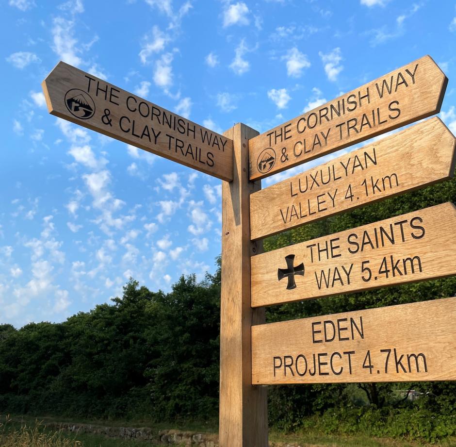
The Saints Way
Snowland Leisure is the ideal location for exploring the Saints Way.
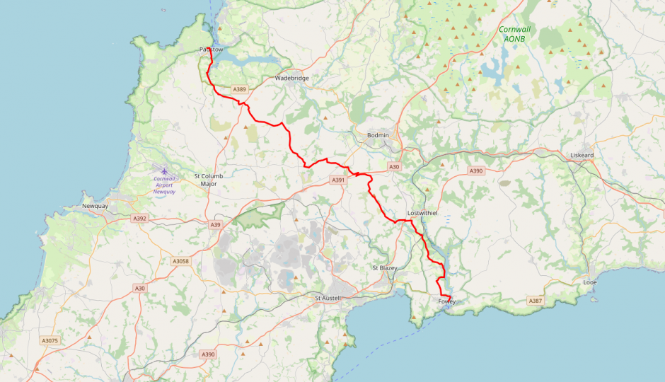
The Saints' Way Trail crosses mid-Cornwall from coast to coast. It covers approximately 30 miles/48 Km from the northern harbour town of Padstow to the southern port of Fowey.
The route starts at Padstow harbour and heads south through Little Petherick, St Breock Downs and Lanivet. The trail then joins the Fowey River near Lostwithiel. You can then walk along the river before reaching Fowey. A shorter route is available approximately 11 miles long. This passes through the Tywardreath site of a medieval monastic settlement.
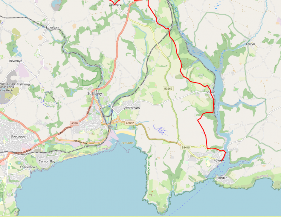
Sections of the Saints Way Close to Snowland Leisure Site
Sections of the Saints Way Close to Snowland Leisure Site
Walking through the Parish of Luxulyan
Length of stage six a - 6 miles/9.6 km
From the Helman Tor Gate the road winds its way with marshland on either side until it gets to Gunwen Chapel. From Gunwen Chapel go south on the road until the next junction and then turn west along the lane with Cornish hedges (stone hedges). Walk past the entrances to Gunwen and Gurtla Farm and continue to Corgee Farm. At Corgee, where the lane forks, proceed south to Tredinnick Farm.
After Tredinnick you leave the lane to join a footpath. Walk along Trenince Drive but before the end of the drive use the stile to cross into Trenince Fields. After another stile and two fields you will enter a copse of trees in the bottom of the valley. You will cross several granite stiles along a cobbled causeway. After walking through the copse walk up the field to meet up with the road again. Cross the road verge to go down the hill into Luxulyan. Enter the churchyard and leave at the south east corner to walk to the Holy Well of St Cyor. Returning up the hill turn left near the Post Office and join the footpath that passes the old school. Cross over the railway line into the field.
Cross this field diagonally and then the next two fields in the same way. After the third field cross the track. After crossing the stile you will enter a small wooded area where you will cross a river. At the top of the hill cross the stile and continue along the path to the next stile. Cross the field and two more stiles and walk along the green lane to Trevanney Farm. Go through the gate at the corner of the farm-yard and walk around the back of the concrete building to rejoin the footpath. Shortly the footpath meets with another footpath - take the path to the south in the direction of Prideaux Farm. Walk up the next field, go across the lane and into the lane to Prideaux Farm. Where the farmyard ends turn to go into the field and walk to the stile to go into Nanscawsen Fields. Cross the field and enter Warren Wood. After walking through the wood you will exit onto a road. Walk down the road past the next junction to enter the Parish of St Blazey.
Walking through the Parish of St Blazey
Length of stage seven (a) - 1/4 mile/400 metres
Walk along the main road - A390 - in the direction of Liskeard. After crossing the bridge over the Luxulyan River and the railway line you enter the Parish of Tywardreath.
Walking through the Parish of Tywardreath
Length of stage eight (a) - 3.75 miles/6 km
Cross the main road near the terrace of old cottages and look for the public footpath sign. Follow the footpath to Kilhallon Farm and then walk in an easterly direction, passing an old well and then walk straight across at the crossroads. Follow the ridge to the Marsh Lane footpath and then follow this down to what was Treesmill Creek and then walk under the railway to arrive in Tywardreath village. Walk through Tywardreath to St Andrew's Church. After looking at the churchyard leave by the east gate onto Well Street.
Cross the A3082 road and walk under the old railway line - now a roadway for china clay trucks. You take up the footpath again between the picturesque almshouses and the Ship Inn public house. Walk up the hill taking care not to cross the stile onto the south west coast-path. Cross the next field in a diagonal direction and cross the stile taking care as you are now on a main road. Cross the A3082. Leave the main road at the signpost for Menabilly and Polkerris and walk towards Tregaminion Farm. Walk through the farmyard, cross the next three fields and you will arrive at the parish boundary with Fowey.
Walking through the Parish of Lanlivery
Length of stage six (b) - 5 miles/8 km
From the signpost for Helman Tor, walk up the road to the Tor and onto its summit. Walk down from the Tor to the car parking area and walk the lane in a south east direction. Stay on the track, ignoring the public footpath sign. After about two miles of walking downhill from the summit of Helman Tor, you will arrive at Menawink. A little more walking and you arrive in Lanlivery Churchtown to visit the Church of St Brevita. Leave the churchyard using the eastern gate and go down the steps to the road. Wakl along the road that is signposted to Lostwithiel passing the camp site. At the nest cottage, named Pelyntor, go through the gate and up the grassy track.
After two more gates and a stile you are again in fields. You continue over the field summit in an easterly direction to the next stile. Cross the stile onto the B3269 road and then ignore the stile facing you. Instead, walk along the road towards No Man's Land where you will reach the junction with the A390. Proceed down the A390 towards Liskeard until you reach the gates of Pelyn House. At this point cross the A390. Walk along the lane and up the hill where you will reach the next turning on the Way. Turn southwards and walk past Crewell Farm. When you reach the gate at the end of the farm lane, go through the gate and walk down the steep path between the tall hedges. Continue to rejoin the minor road at Castle. Continue walking along the road to the next junction at Pelyn Bridge where you should follow the road towards Milltown which follows the river. At the small hamlet of Milltown continue along the lane and walk under the railway bridge. After passing two granite posts you are now in the Parish of St Sampson.
Walking through the Parish of St Sampson
Length of stage seven (b) - 3 miles/5 km
St Sampson is the penultimate parish on this route of the Saints' Way. Walk up the lane passing the the back of Lantyan farmhouse and continue along the lane in a southerly direction. Cross the next stream and walk up the hill. When you reach the second gate cross the stile into the field. After three stiles cross the youth hostel driveway and proceed in a diagonal direction across the field. Cross the next stile in the field's hedge and walk across the next field in the direction of the lane that will take you to St Sampson's Church.
Walk down Church Hill and School Hill to reach the village of Golant. At the crossroads walk straight across as far as Hendra House, turn and walk between the two gateposts to leave the village. You are now walking onto Golant Downs. The pathway brings you close to Sawmills Creek. After crossing the stepping stones you have entered the Parish of Fowey.
Entering Fowey from St Sampson Parish
Walking through the Parish of Fowey
Length of stage eight (b) - 2 miles/3.25 km
Head away from Sawmills Creek uphill and inland through Colvithick Wood. When you emerge from the wood carry on uphill and you will reach a group of derelict buildings. This is Penventinue Lane. The Saints' Way is clearly marked with signposts at this point. Head downhill, crossing the old Fowey railway line which is now a road for china clay trucks, to join the B3269 road to Fowey. On reaching the end of North Street just before Fowey's Post Office, walk up to your right onto the Bull Hill footpath. Follow this footpath to the Church of St Fimbarras. Your journey along the Saints' Way is now complete.
Entering Fowey from Tywardreath Parish
Walking through the Parish of Fowey
Length of stage eight (a) - 2 miles/3.25 km
You enter the Parish of Fowey through Trenant. Walk along beside the upper hedge of the field then cross the stile to take you into Lankelly Woods. An arched bridge crosses the Saints' Way here as it makes its way to Menabilly House.
Cross the next stream then walk up the hill to Lankelly. At Lankelly turn to the south and proceed along the road to Polridmouth. At the next turning go east and then shortly afterwards turn into Love Lane. This old lane, owned by the National Trust, will take you to Readymoney Cove. Walk along the Esplanade and through Fowey's streets to reach the Church of St Fimbarras. You have now completed your journey along the Saints' Way.